Start hereIn 1707, five ships of a British fleet struck rocks off the Isles of Scilly and more than 1,400 men died; navigational errors were the cause. Today a phone finds you to within a few metres. What happened in between?
Knowing exactly where you are is new. For most of history, sailors could read how far north or south they were from the sky, but finding how far east or west meant knowing the time somewhere else. Today a phone is typically accurate to within 4.9 metres under open sky, says the US government’s GPS site. Here is how it changed, and one small way to use what you have.
1. Before: the sky, a clock and a guess
Sailors could find how far north or south they were, but not how far east or west. That north–south position is called latitude; the east–west one is longitude.
Latitude can be found from the position of the Sun or the pole star, but longitude is harder because there are no natural references to measure it from. Longitude is really a difference in time: one hour of difference in local time equals 15 degrees of longitude. A navigator also had to know the time at a reference place, and that was the difficult part.
For example, if a clock set at home reads three in the afternoon when the Sun is highest where you are, you have come 45 degrees west.
Mistakes could be deadly. On the evening of 22 October 1707, five ships of Admiral Sir Cloudesley Shovell’s fleet struck rocks off the Isles of Scilly, and more than 1,400 men died. Navigational errors were the cause. Even so, Royal Museums Greenwich finds no evidence of a public outcry afterwards; the Longitude Act seems instead to have come from lobbying by mathematicians such as William Whiston.
The Longitude Act and Harrison’s clocks
Britain offered a fortune for finding longitude at sea, and a self-taught clockmaker took up the challenge.
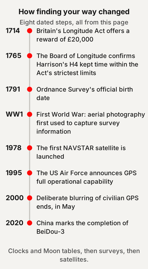
On 9 July 1714, Queen Anne gave royal assent to an act offering a public reward for finding longitude at sea. The reward was £20,000, which Royal Museums Greenwich says would be worth at least £1,500,000 today. Spain had set up the first such reward in 1567.
John Harrison, a carpenter who taught himself clockmaking, aimed for a portable clock that kept time to within three seconds a day. In 1761 his fourth timekeeper, H4, was cleared for a trial voyage to Jamaica, and in 1764 it went on a second trial, to Barbados. In February 1765 the Board of Longitude confirmed that H4 had kept time within the strictest limits of the 1714 Act. In other words, Harrison’s idea was to carry the home port’s time on board, in a clock that a ship’s motion would not upset.
2. How it changed
Finding your position got easier in steps: clocks and Moon tables, then mapped countries, then satellites.
Clocks and the Moon
By the 1760s there were two working methods, and over the following decades navigators came to use both. In short, the clock and the Moon tables worked side by side more than against each other. By then two astronomical rivals to Harrison’s clock had emerged: the lunar method and Jupiter’s moons. The lunar method used the Moon’s position, with tables of its future positions worked out in advance.
On a 1761 voyage to St Helena, the astronomer Nevil Maskelyne found his longitude by the Moon to within 1½ degrees, where the usual method, dead reckoning, could be out by up to 10 degrees. He then set up the Nautical Almanac, whose tables for 1767 were ready to print by the end of 1766.
Clocks were slow to spread. Marine timekeepers stayed rare and expensive, and it took decades for sailors to trust them. Simpler, cheaper designs brought wider use of marine chronometers at the start of the 1800s.
Mapping whole countries
Here is how one country was mapped: with networks of triangles, and later from the air. The example here is Great Britain.
Ordnance Survey, Britain’s mapping agency, counts 21 June 1791 as its official birth. Its first map, of Kent, was published in 1801. The first maps sold for three guineas per county survey, between one and three weeks’ wages for the average person.
In practice, surveyors measured angles across a chain of triangles from one carefully measured line. In the First World War, Ordnance Survey staff posted overseas plotted the lines of trenches, and aerial photography was used for the first time to capture survey information.
The white concrete pillars on many British hilltops were built for the Retriangulation of Great Britain, launched in 1935: around 6,500 were put up, and many still stand.
By the 1960s, aerial surveying helped speed up Ordnance Survey’s new “continuous revision” of its maps. In 1990 it began work on a national satellite positioning network to replace the triangulation network.
Satellites overhead
Satellite positioning took nearly two decades to build, and the deliberate blurring of civilian signals ended in 2000.
The US Department of Defense launched its first NAVSTAR satellite in 1978. Sources give two dates for when the system was complete, because there were two milestones. On 8 December 1993, Air Force Space Command declared initial operational capability, with 24 satellites operating; NASA’s history gives 1993 as the year the 24-satellite system became fully operational. The US Air Force announced full operational capability on 17 July 1995, with 24 satellites in orbit.
In the 1990s, a feature called Selective Availability deliberately made civilian GPS less accurate across the whole world. It was switched off a few minutes after midnight, US Eastern time, at the end of 1 May 2000, across the whole constellation at once.
GPS is one of several such systems; the general name for them is global navigation satellite system, or GNSS. Russia’s GLONASS was declared operational in 1993 and reached a full constellation of 24 satellites in 1995. After funding cuts it was down to 7 satellites in 2002, and a programme to rebuild it began that year. Europe’s Galileo began initial services on 15 December 2016. China marked the completion of its global BeiDou-3 system at a ceremony on 31 July 2020.
For example, a receiver that can use several of these systems has more satellites to choose from.
3. What the numbers say now
A phone is typically accurate to about five metres under open sky, and less accurate among buildings and trees.
GPS-enabled smartphones are typically accurate to within a 4.9 m (16 ft) radius under open sky, says GPS.gov. GPS.gov takes the figure from a 2015 conference paper in which more than a thousand people in one hundred countries measured their smartphones, with a mean accuracy of 4.9 metres. Accuracy gets worse near buildings, bridges and trees. Professional receivers using two frequencies or correction systems can reach a few centimetres in real time.
What you get depends on the signal, how much sky you can see, and your device. The US government commits to a signal error, called user range error, of no more than 2.0 metres on a daily global average, 95% of the time. On 20 April 2021 the measured figure was 0.643 metres or better, 95% of the time. GPS.gov adds that this signal error is not the same as how accurate your device is.
GPS satellites orbit about 20,200 km up and circle the Earth twice a day. The layout of 24 slots lets users see at least four satellites from virtually any point on the planet. The United States commits to at least 24 operational GPS satellites, 95% of the time. With two frequencies as standard, Galileo can give real-time accuracy down to the metre range, says the European Space Agency.
4. Things people often repeat
Five popular ideas about maps and GPS, and what the sources say.
“Medieval maps showed a flat Earth”
Doesn't hold up Medieval world maps show that people then thought the Earth was flat. Many medieval maps were teaching diagrams, and educated people knew the Earth was round. For example, a “T-O” map draws the known lands as a circle split by a T of waters, much as a school diagram simplifies a globe.
How sure: Strong two major libraries and the historians in our flat-Earth article agree.
Yale’s Beinecke Library says medieval Europeans were well aware that the Earth was curved, and that these maps often note they are simply diagrams useful for instruction. The British Library’s manuscripts blog adds that the medieval belief in a round Earth “was also reflected in many medieval maps”. Our page Medieval People Did Not Think the Earth Was Flat tells the full story.
“Columbus proved the Earth was round”
Doesn't hold up Columbus sailed west to prove the Earth was round. Columbus did not have to persuade experts that the Earth was round. Columbus thought the world was small enough to reach Asia by sailing west. The Americas lay in between.
How sure: Strong the medieval texts and the historians who traced the story agree.
“John Harrison solved longitude on his own”
Partly Harrison’s clock alone solved the longitude problem. His H4 met the Act’s strictest test, but the Moon method worked too, and navigators could use both.
How sure: Moderate it rests mainly on Royal Museums Greenwich, which keeps Harrison’s clocks and tells both sides.
The museum notes that Harrison has long been portrayed as the plucky underdog, and that this has tarnished the reputation of the astronomer Nevil Maskelyne. The astronomer James Bradley concluded that Moon tables by Tobias Mayer, with a good instrument, could find a ship’s longitude to within 1 degree, which brought them inside the limits of the 1714 Act. It adds that dead reckoning would not be abandoned soon, and that those who took up the new techniques might use all the methods rather than choose one.
“GPS satellites track where you are”
Doesn't hold up The GPS satellites know where you are. The satellites only send signals; your device works out its own position. Whether your phone or its apps share that position is a separate matter.
How sure: Strong it is how the system is built, as its operators describe it.
GPS.gov says the satellites do not track anything on the ground: they are simply beacons, like lighthouses, broadcasting one-way reference signals. The receiver uses those signals to calculate its own position and time. If you lose a phone, GPS.gov suggests your wireless carrier, which may be able to locate it using the location technology built into it.
“Civilian GPS is made less accurate on purpose”
Doesn't hold up The US still blurs GPS for ordinary users. That was true in the 1990s, under a feature called Selective Availability, and it ended in May 2000. GPS.gov adds that the blurring was worldwide and could not be applied to one region only; instead, it says, the military is developing ways to deny GPS to adversaries in a region.
How sure: Strong it is official US policy, made lasting when new satellites were ordered without the feature.
GPS.gov says the United States has no intent to ever use Selective Availability again. In September 2007 the US government decided to buy its next generation of satellites, GPS III, without the feature.
5. One small way to use it better
Before a long trip, save the map you need on your phone and carry a backup. For example, download the area around a hiking trail at home, where you have a good connection.
Google’s Maps help explains how to save an area to your phone or tablet and use it when you are offline. It notes that offline maps cannot be downloaded in some countries or regions. OpenStreetMap, built by a community of mappers, says its data is free to use for any purpose as long as you credit OpenStreetMap and its contributors, and that if you alter or build upon the data in certain ways, you may share the result only under the same licence.
GPS.gov strongly encourages all GPS users to keep a backup way of finding position, navigation and time. In practice, that can be a saved map or a paper one.
If a map shows your street in the wrong place, the satellites are not to blame. GPS.gov points out that the satellites only provide location signals, not maps, so a map error must be reported to the company that made the map.
Our suggestion: the next time a blue dot finds you in seconds, remember the fleet lost off the Isles of Scilly in 1707.
Quick answers
Who solved the longitude problem?
No single method did. John Harrison's H4 kept time within the strictest limits of the 1714 Longitude Act, and the astronomer James Bradley concluded that Moon tables with a good instrument also came within the Act's limits. Navigators who took up the new techniques might use all the methods rather than choose one.
When did GPS start?
The first NAVSTAR satellite was launched in 1978. Air Force Space Command declared initial operational capability on 8 December 1993, and the US Air Force announced full operational capability on 17 July 1995. NASA's history gives 1993 as the year the system became fully operational.
How accurate is GPS on a phone?
GPS.gov says smartphones are typically accurate to within 4.9 metres under open sky. Accuracy gets worse near buildings, bridges and trees.
Can GPS satellites track me?
No. GPS.gov says the satellites do not track anything on the ground; they broadcast one-way signals. Whether your phone or its apps share your position is a separate matter.
Did medieval maps show a flat Earth?
No. Many were teaching diagrams: Yale's Beinecke Library says medieval Europeans were well aware that the Earth was curved, and that these maps often note they are simply diagrams useful for instruction.
Use this
Three small ways to use the position you have, drawn from the sources above.
What did knowing this cost people before it became easy?
Quick quiz
Nothing is scored or saved. Recalling it once now is what makes it last.
1. Why was longitude so hard to find at sea?
Answer: You needed to know the time at a reference place.Read it again ↑
2. When was Selective Availability, the deliberate blurring of civilian GPS, switched off?
Answer: May 2000.Read it again ↑
3. What do GPS satellites send?
Answer: One-way signals your device uses to work out its position.Read it again ↑
How we checked this · Last checked October 2026
- We read the longitude story in Royal Museums Greenwich's own pages, and one example of national mapping in Ordnance Survey's history.
- GPS facts come from GPS.gov, NASA and the US Air Force; the other satellite systems come from their operators' own sites.
- Sources give 1993 or 1995 for when GPS was complete; these are two milestones (initial and full operational capability), and the page gives both.
- GPS.gov's pages give different satellite counts, so we give only its commitment of at least 24.
- The flat-Earth and Columbus items use the same wording and sources as our reviewed page on the medieval flat-Earth myth.
- The US Air Force and Space Force stories, a Yale library page and a British Library blog post did not open for us directly, so we read Internet Archive copies.
Sources
- Royal Museums Greenwich, “What is longitude?”, “What made the search for longitude so important?”, “Longitude found: the story of Harrison’s timekeepers” and “Longitude found: Nevil Maskelyne and the lunar method”.Scholarly
- Ordnance Survey, “Our history”.Primary
- NASA, “Global Positioning System History”.Primary
- Mike Slater, “GPS: A generation of service to the world”, U.S. Air Force, 2015 (Internet Archive copy).Primary
- GPS Directorate, “20th Anniversary of Initial Operational Capability of the GPS Constellation”, Los Angeles Air Force Base, 2014 (Internet Archive copy).Primary
- Frank van Diggelen and Per Enge, “The World’s first GPS MOOC and Worldwide Laboratory using Smartphones”, Proceedings of ION GNSS+ 2015, pp. 361-369.Scholarly
- GPS.gov, “GPS”, “GPS Accuracy”, “Selective Availability”, “Space Segment”, “FAQ”, “My Address Is Wrong!” and “Other Global Navigation Satellite Systems”.Primary
- GLONASS Information and Analysis Center, “About GLONASS”.Primary
- European Space Agency, “What is Galileo?”.Primary
- BeiDou Navigation Satellite System, “Xi attends launch ceremony for BeiDou-3 Navigation Satellite System”, 31 July 2020.Primary
- Beinecke Rare Book & Manuscript Library, “Medieval World Maps (T-O Maps)”, 11 July 2022 (Internet Archive copy).Scholarly
- Alison Hudson, “‘The Earth is, in fact, round’”, British Library Medieval Manuscripts blog, 24 May 2018 (Internet Archive copy).Scholarly
- Darin Hayton, “Washington Irving’s Columbus and the Flat Earth”, 2 December 2014.Popular
- Google Maps Help, “Download areas & navigate offline in Google Maps”.Primary
- OpenStreetMap, “About OpenStreetMap”.Primary
Your position once took skill
Royal Museums Greenwich explains that latitude could be read from the Sun or the pole star. Longitude meant knowing the time at a reference place, and that was the hard part. GPS.gov says phones are typically accurate to within 4.9 metres under open sky, the average found in a 2015 study. Our view: a dot that once took clocks, tables and skill is worth understanding, not only following.
Read a "who invented it" claim
- Name every method. By the 1760s, Royal Museums Greenwich says, Harrison's clock had two astronomical rivals. They were the lunar method, using tables of the Moon's future positions, and Jupiter's moons.
- Check what each one passed. In February 1765 the Board of Longitude confirmed H4 kept time within the Act's strictest limits. The astronomer James Bradley concluded that Tobias Mayer's Moon tables, with a good instrument, also came within the Act's limits.
- Ask when it spread. The museum says marine timekeepers stayed rare and expensive, and it took decades for sailors to trust them. Simpler, cheaper designs brought wider use at the start of the 1800s.
- Ask how people really worked. The museum adds that those who took up the new techniques might use all methods rather than choose one.
- Our suggestion. Before you credit one inventor, ask which rival methods existed, and when each came into wide use.
This week: test your dot
Our suggestion: this week, open a map on your phone once under open sky and once indoors. Each time, note how far the dot sits from where you really stand, and whether it wanders. GPS.gov's 4.9-metre figure is for open sky. What you get also depends on how much sky you can see, and on the device itself. Our view: comparing your two readings shows that difference for yourself.
Keep going
- Things we take for granted: the calendar and clock timeHow the calendar and the clock came to be shared, and why the leap second is ending.
- Medieval people did not think the Earth was flatWhat medieval scholars wrote about Earth's shape, the few dissenters, and how the flat-Earth myth spread.
- Things we take for granted: electric lightWhat light cost before electricity, how it changed, and who still lives without it.
- Things we take for granted: clean tap waterHow tap water went from dangerous to normal, and where it still is not.
- Things we take for granted: vaccinesWhat life was like before vaccines, how it changed, and what the numbers say now.
- Things we take for granted: writing and literacyWhen writing began, why reading stayed rare for so long, and how many people still cannot read.
- Things we take for granted: refrigerationHow food was kept before fridges, how mechanical cold arrived, and what food agencies say about it now.
- Things we take for granted: the internetHow messages travelled before the internet, how the network and the web arrived, and who is online now.
- GlossaryPlain meanings of latitude, longitude, GNSS and Selective Availability, the terms used on this page.